
Elephant Mountain (象山 or Xiangshan) is a mountain in eastern Taipei City. The relatively short trail up the 184-meter mountain provides unbeatable city views, making it Taipei’s most famous hike and one of Taiwan’s most well-known attractions.
The Elephant Mountain trailhead is a mere 0.85 km (0.5 mi) from Taipei 101. This means you can hop directly from the country’s most famous landmark and ritziest neighborhood to a natural, jungle setting in less time that it takes to crush one bubble tea.
I’ve personally hiked Elephant Mountain and its connecting trails at least half a dozen times. These trails offer several of the best views of Taipei 101 in the city. Most recently, I hike it before doing Skyline 460 (standing on the roof of Taipei 101).
In this article, I’ll share some pro tips for finding the way, beating the crowds, the best lookout platforms, a trail map, how to see the elephant shape, and some other less touristy trails in the surrounding Four Beasts Scenic Area.
Elephant Mountain Introduction

Elephant Mountain (184 m) is one of several peaks or connecting hills of Nangang Mountain (南港山, 375m). Elephant Mountain is the peak that’s closest to Xinyi district and Taipei 101, so it is by far the most popular trail.
Xiangshan is one of the “Four Beasts” (四獸山 or Sishoushan), along with Lion Mountain (獅山 or Shishan), Leopard Mountain (豹山 or Baoshan), and Tiger Mountain (虎山 or Hushan). These are protected as the Four Beasts Scenic Area.
These four connected peaks are supposedly shaped like the four animals they are named after – you can attempt to spot their shapes from the Taipei 101 Observatory.
In the below photo, the thin, shaded green strip of land in the middle is (I think!) supposed to be the elephant’s trunk.

Behind Elephant Mountain, the taller Nangang Mountain has a long ridge (see center of photo above) with two twin peaks:
Thumb Mountain (拇指山) to the south (right side of above pic) and and 9-5 Peak (九五峰) to the north (left side). You can climb to both of these as a continuation of Elephant Mountain Trail.
These two peaks offer Taipei views similar to Elephant Mountain, but even better because they are higher up and less crowded. I’ll describe how to climb both of them at the end of the article.
How Long Does It Take to Hike Elephant Mountain?

In total, you can expect it to take about 1.5 hours (return) to complete Elephant Mountain trail from Xiangshan MRT station. This is at an average walking speed, with time included for taking photos and breaks.
If you’re a fast hiker and don’t need many breaks or photo stops, you could probably hike to Elephant Mountain Peak and back to Xiangshan MRT in one hour.
If you want to hike a little longer and explore more than just the most touristy trail, I’m going to recommend a nice little hiking loop past the famous viewpoint that will take an additional 20 minutes, for a total of just under two hours.
If you want to hike Elephant Mountain, Thumb Mountain, and 9-5 Peak, budget 3 hours or more if you plan to stop a lot, visit the temples, take lots of photos, etc. If you want to conquer all four beasts, that’s an easier choice and will take about 2.5 hours or more.

Here are some hiking times I recorded on my most recent visit. You’ll need to add more time for breaks/photo taking – these are just the actual walking times.
- Xiangshan MRT to Elephant Mountain Trailhead: 10 minutes
- Trailhead to Xiangshan Photographer’s Platform: 15 minutes
- Xiangshan Photographer’s Platform to Six Boulders: 10 minutes
- Six Boulders to Elephant Peak: 5 minutes
- Back to MRT: 30 minutes
- Additional Loop: Add 20 minutes
I’m going to describe each of these sections in more detail below!
How Hard (and Safe) is the Hike?

Elephant Mountain Trail is considered a moderate hike. How hard that is for you is going to depend largely on factors like your fitness level/hiking experience and the weather.
The walk from the MRT station to the trailhead is mostly flat, but the road goes uphill for a few minutes at the end – just a tiny warm-up for what lies ahead.

The 25-minute climb from the trailhead to the Six Boulders is the hardest part. The trail consists of uphill stairs the whole way. The stairs get fairly steep towards the top (see photo above).
The trail flattens out again from Six Boulders to Elephant Peak.
If you this hike anytime from June to September, the intense summer heat and humidity will be a factor to consider.
Make sure to bring water and appropriate protection. Most of the walk has shade from trees, but there are some exposed sections and lookouts.

Elephant Mountain trail is safe to walk even at night – there are lights along the whole trail.
]However, one thing to be aware of is the presence of poisonous snakes in the jungle, like anywhere in Taiwan. Very few people encounter them, and I don’t mean to freak you out, but just be aware that they are there. Simply watch your steps and don’t go wandering off the trails and you’ll be fine!
If you’d like to hike past Elephant Mountain to Thumb Mountain and 9-5 peak, this is a longer but not necessarily much harder hike. You’ll make twice the elevation gain compared to just doing Elephant Mountain.
Best Time to Do the Trail

In my opinion, the best time to do Elephant Mountain is early in the morning. Sunset is also a great time but is significantly more crowded.
The first Red Line MRT of the day will get you to Xiangshan MRT at 6:05 AM. This will be early enough to make it to the Elephant Mountain viewpoint for sunrise in winter, but not in summer when the sunrise is as early as 5 AM.
Since the Elephant Mountain lookouts face west, you can watch Taipei City light up as the sun rises and illuminates the city.
On my last visit, I arrived at Xiangshan MRT at 8 AM. This was still an excellent time to do the trail. There were relatively few people on it, it wasn’t too hot yet, and Taipei weather has a higher chance to be clear in the morning.

Sunset is also a great time to climb Elephant Mountain, since you’ll get to watch the sun setting over Taipei City.
I suggest that you plan to be at the top at least 30 minutes before the actual sunset time, because you don’t want to miss the changing colors of the sky before the sun actually reaches the horizon.

The major downside here is that this is by far the busiest time to be on Elephant Mountain. You can expect crowds of people on the famous lookout platforms.
Personally, I would avoid doing Elephant Mountain in the late morning or early afternoon in hot weather. If you are totally accustomed to summer weather in Taiwan, then go for it. You’ll have the trail mostly to yourself, because few people dare to hike in that heat!
For more information about weather and a monthly temperature chart I made, see my guide to the best time to visit Taiwan.
Watching New Year’s Eve Fireworks from Elephant Mountain
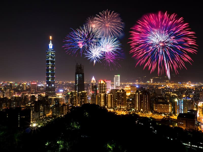
Because Elephant Mountain has such an excellent (and close!) view of Taipei 101, it’s one of the most obvious places to watch the Taipei 101 Fireworks on New Year’s Eve (Dec 31 at midnight).
However, space on Elephant Mountain’s platforms is so limited that I would personally never even imagine trying to watch the fireworks from there. Masses of local photographers usually claim all the best spots as early as 16 or more hours in advance.
Closer to the time, so many people will crowd onto Elephant Mountain trail that it will become totally clogged.
A smarter thing to do would be to hike up to one of the higher peaks, like Thumb Mountain or 9-5 Peak, starting not from Elephant Mountain but from Houshanpi MRT and Tiger Mountain Trail to the north.
But this trick is no secret, either, and you can expect even those higher peaks to be very crowded with fireworks watchers on NYE. You might need to arrive hours in advance to get a decent spot. For less crowded options, see the article I linked to above.
Elephant Mountain Trail Map

I’ve created the above map of Elephant Mountain Trail and other trails in the Sishoushan (Four Beasts) Scenic Area. Here are the color codes of the trails:
- Blue: Xiangshan MRT to trailhead
- Red: Elephant Mountain Trail
- Orange: An extra loop I’ll recommend
- Green: Trail to Thumb Mountain and 9-5 Peak of Nangang Mountain
- Purple: Trail to Lion, Leopard, and Tiger Mountains
Also note the locations of Taipei 101, Xiangshan and Houshanpi MRT stations, and the Guanyin Statue I marked (turnoff point to the other three beasts).
Getting to Xiangshan Trailhead
Pro Tip: Breakfast on the Way
Since you’re most likely taking the MRT Red Line to Xiangshan, get off at Da’an station and walk to Yonghe Soy Milk here, one of the most famous Taiwanese breakfast shops in Taipei.

It’s an easy, 10-minute walk from Xiangshan MRT (exit 2), the terminal station of the MRT Red Line, to the Elephant Mountain trailhead, which is here.
Note that there are luggage storage lockers is the the MRT station if you need to leave anything there. Here’s how to use the lockers.

You’ll be walking south along Xiangshan Park most of the way.
The long, skinny park at the base of Elephant Mountain has some love green space, a restroom, a small temple, and even a few cherry blossom trees (find out when to see cherry blossoms in Taipei).

When you reach a dead end at the southern end of the park, turn left and walk up the car road. The road goes uphill for just one minute, but it’s enough to get me breathing hard!

The road turns to the right, where you’ll notice some a sign pointing to Elephant Mountain. A large temple called Daitiandian Lingyun Temple (代天殿靈雲宮) stands to the left. The trailhead is just past the temple, also on the left.
You can’t miss the trailhead – there’s a large sign and map of the trail system topped with a cute cartoon elephant (see photo above), on either side of the staircase going up.
Hiking Up Elephant Mountain Trail
Now that’s we’ve reached the trailhead, I’ll separate my Elephant Mountain Trail guide into sections – the same sections I described above.
Trailhead to Xiangshan Photographer’s Platform (15 min)

From the moment you start the trail, it’s all stairs, all the way. Right off the bat, note the cute little elephant designs on the side railings.
After only one minute, you can turn left to take a look at the main shrine in Daitiandian Lingyun Temple. Then your upward march continues!

After 5 minutes, the trail splits, with a sign pointing to multiple destinations to the left and right.
The destinations indicated to the right are “Mt. Xiangshan 480 m 16 min” (peak of Elephant Mountain) and Liu Ju Shi 330 m 11 min” (this refers to the Six Boulders area). This is where we are headed, so follow the sign to the right!

Shortly after you make the turn, the stairs get steeper. You can start to see glimpses of Taipei City through the trees to your left. You can sneak peeks at some ultra-luxurious apartments with swimming pools!
About 15 minutes from the time you started the trail, you’ll reach the first viewing platform, which is called Xiangshan Photographer’s Platform (象山攝影平台, here on GoogleMaps).

Note that we’ll be returning to this exact spot, but from different trail, at the end if you decide to follow the additional loop that I’m going to recommend below.
Xiangshan Photographer’s Platform offers a fantastic view of the city. This will most likely be your first major break stop. From here, Taipei 101 looks so close it feels like you could just about reach out and touch it.

Besides taking city photos from the platform itself, you can also take excellent photos of your friends on the platform by walking up a few of the stairs that you’ll soon be taking (that’s how I shot both of the photos here).
In my case, hiking alone, I just took photos of some strangers : )
Xiangshan Photographer’s Platform to Six Boulders (10 min)

Continuing along, go up the stairs directly opposite the platform, which continues to go up the mountain. In other words, don’t take the trail to the left (you’ll be coming back on that trail if you do the additional loop at the end).
Within five minutes, the stairs get extra steep just before the final stretch to Six Boulders. You’ll know you’re close when you see the giant stone at the top, painted white, with the red characters 象山 (Xiang Shan) etched into it.
The Six Boulders (六巨石) lie just above that stone.

The Six Boulders are an iconic sight on Elephant Mountain. In the past, these massive sedimentary stones were a famous spot for viewing the city.
However, nowadays, the vegetation around them is all but blocking the view.
Although a sign says not to, many people climb up the boulders to get a better view or pose for pictures. There are even steps carved into the stone to help people climb up (see below picture).

Don’t worry about the lack of view, though. Elephant Mountain’s best view of Taipei is just around the corner. Walk just a few steps past the stones and watch for a sign pointing to the left.
Follow that trail up just a few more steps to find the Xiangshan Six Boulders Observation Deck (象山六巨石觀景台). Note: some signs in the area call this “Photographer’s Lookout” (攝影平台), which is confusingly the same name as the last platform we visited.
This is, in my personal opinion, the best lookout platform on Elephant Mountain.

Take in the city view in all its glory. Note the “green fingers” of forest which stretch out into the otherwise dense urban sprawl. One of these, which you can see by looking to the right, is the supposed trunk of the elephant (大象長鼻).
For most visitors, this is the farthest they will go. You can hike a little further to the actual peak of Elephant Mountain (see next section) and then do my recommended loop (see two sections below), or just go back down the way you came from here.
Six Boulders to Elephant Peak (5 min)

The actual peak of Elephant Mountain is a bit anti-climactic, but still worth going and not too difficult. On the way, you’ll climb a set of stairs beside a huge boulder covered in green moss (see photo above).
At the peak (here), you’ll found a small peak marker, but no view. If you follow a small path through the trees, there’s a tiny lookout point with an elephant-shaped bench framing the view.

Spread around the peak area, there are some exercise equipment for the elderly, several benches and little platforms (one is even called the “Marriage Proposal Platform” (象山求婚平台), and some public restrooms.
Additional Loop (20 min)
At this point, if you’d like to hike just a bit further before going back, then proceed with this additional loop. You’ll gain several more city views and get a little off the most well-beaten track (related: see my guide to getting off the beaten track in Taipei).
The cluster of benches, platforms, and trails at the peak of Elephant Mountain can be a little disorienting, with trails going off in several directions. Follow the signs pointing to Chaoranting (超然亭) and Yongchungang Platform (永春崗平台).

After just a few minutes, the mostly flat trail reaches Chaoranting (here), which translates as “Transcendent Platform”.
The view from here is transcendent indeed! It won’t be much different than what you saw from Six Boulders Observation Deck, but slightly different angle, and usually less people. The large covered platform is also a great spot to rest in the shade or have a snack.
Continuing along, the trail through the forest remains mostly flat, with occasional city views through the trees to your left. After five minutes, you’ll reach Yongchungang Platform (here).

Unlike all the other platforms so far, this one faces north instead of west, so you can see a totally different part of the city. You’re actually looking directly toward Raohe Night Market, Keelung River, and in the distance, Yangmingshan National Park.
From there, follow the set of stairs steeply downhill to the left. At the bottom of the stairs, there’s another viewing platform facing west, but partially obstructed by trees. You can see Taipei 101 again from here, but from a very different angle than earlier (see above photo).

Take a hard left here, walking past a huge boulder with Mandarin characters carved into it, as in the image above.
Continue for five minutes to A Thread of Sky (一線天, here), a narrow crack between two huge stones. You’ll have to duck down a little to make your way through the cave-like passage.

A few minutes after A Thread of Sky, you’ll reach Big Rock Wall (大岩壁), a towering wall of sandstone with orange coloring – the result of oxidization of iron in the stone.
Continue walking straight, avoiding staircases going up and down on either side. You’ll arrive at Yongchun Pavilion (永春亭, here), which is a small covered resting pavilion in the forest.

This spot can be a little disorienting, too, with paths going in several directions. Walk past the pavilion, then follow signs pointing to Photographer’s Platform (攝影平台), referring to the first viewing platform we visited today.
The Photographer’s Platform is just a few steps away. From there, you’ll keeping following the steps downhill the way you came up, and finally back to the MRT.
Hiking Trails to Other Peaks in Four Beasts Scenic Area
There are many hiking trails and routes you could take to the other mountains connected to Elephant Mountain.
Here’s a government-made map of the main hiking trails in Four Beasts Scenic Area, but I’ll link to relevant AllTrails maps below, too.
Nangang Mountain (Thumb Mountain and 9-5 Peak)

If you’d like a longer and slightly more challenging add-on to your Elephant Mountain climb, this route is for you.
From Elephant Mountain peak, you can continue to Thumb Mountain and 9-5 Peak, which are the two main peaks of Nangang Mountain. They offer Taipei views similar to Elephant Mountain, but better because they are higher up. They will also have fewer people.
Thumb Mountain is named after a cluster of stones at the peak which supposedly look like a thumb. From its peak, you’ll have a commanding, 360-degree view. Taipei, with the hump of Elephant Mountain at the bottom of Taipei 101, is on one side, with Muzha district and Maokong Gondola behind on the other side.
From there, you’ll follow the ridge to Nangang Mountain South Peak (which you’ll barely notice as you pass it) onward to 9-5 Peak, which is the true peak and highest point of Nangang Mountain. At the peak, watch for a rock with the characters 九五峰 (9-5-Peak), which many hikers stand on to pose for their photos.
The peak is named after a 95-year-old Taiwanese man who climbed the mountain many years ago, when it didn’t have such trails and was much more difficult to climb.
In total, this hike should take about 3 hours, with the possibility to go back the way you came to Xiangshan MRT, or to hike down the northern side to Tiger Mountain and Houshanpi MRT via the remote Songshan Cihui Temple (松山慈惠堂).
This AllTrails Map covers the whole route to 9-5 Peak and back to Xiangshan MRT. If you want to do Elephant Mountain and Thumb Mountain only, use this map.
If you want to finish at Houshanpi MRT, this AllTrails map starts from Xiangshan Park (point 1), up Elephant Mountain (2) to Thumb Mountain (7), then to 9-5 Peak (8). From there, it goes down the north side of the mountain, connecting to Tiger Mountain, and finishing in the city near Houshanpi.
Because there are so many different connecting trails, it can be easy to go the wrong way. I suggest using the AllTrails map while hiking, and yes, there’s a signal on the mountain.
The Other Beasts (Lion, Leopard, and Tiger Mountains)

It’s easy to “conquer” all four beasts in one go, but the views simply aren’t as grand as Thumb Mountain and 9-5 Peak, because none of these mountains (more like hills) are nearly as high. However, there are several remote temples and cliff carvings to explore.
For the route I’ll describe below, budget around 2.5 hours from Xiangshan MRT to Houshapi MRT, and it’s an easier hike than the above entry, with less elevation gain.
From Elephant Mountain Peak, continue along the Xiangshan Trail (象山步道) to a large statue of Guanyin called Guanyiting (觀音涼亭, here, also marked on my map above) and Songshan Lingyin Temple (松山靈隱寺) beside it.
Just before the statue, turn left and follow a trail to a small vehicle road (Songshan Road 松山路). From that road, another short trail leads up to Lion Mountain Peak (獅山峰), here on GoogleMaps).
This is probably the least interesting of the Four Beasts. There are no grand views from this peak, but if you’re looking for solitude, you may enjoy the short trail.
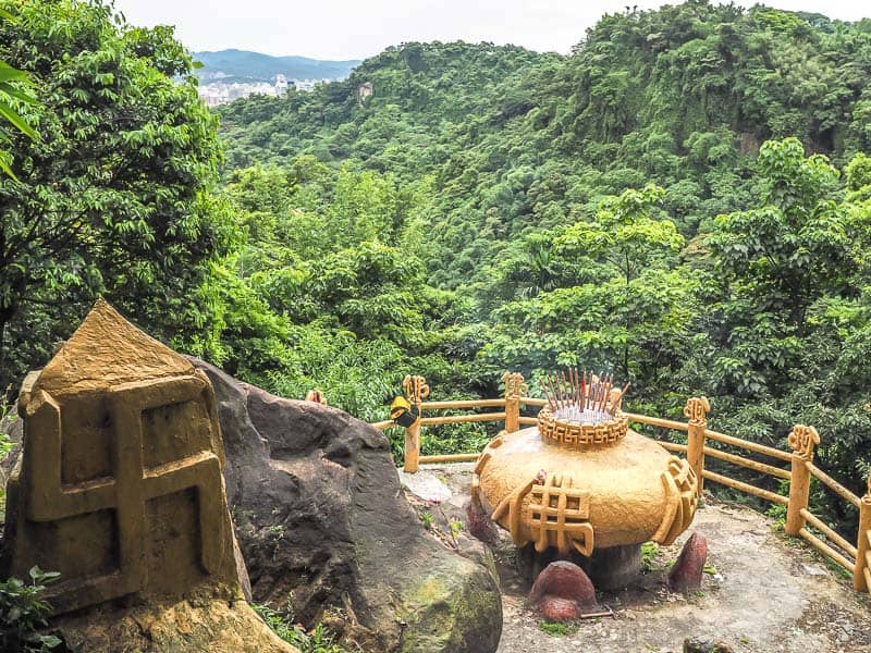
Returning to Songshan Road, make a small detour to Tianbao Shengdao Temple (天寶聖道宮, here), where you can see a large god carved into a cliff (see above photo) and other cool statues.
Return to Songshan Road again and follow it east past a few small temples to this coal mining tunnel, near which a small car road and path lead up to Leopard Mountain Peak (豹山峰, here).
This peak actually does have a great view of Taipei. Watch for the leopard designs on the railing.
After that, it’s only a few steps away to Tiger Mountain Peak (虎山峰, here), which also has an excellent city view.
From there, you could continue along Tiger Mountain Trail (虎山步道) back to the city and Houshanpi MRT via Jifu Temple (吉福宮, here).
Otherwise, you can further explore the network of trails on Tiger Mountain (use this map), finishing at one of two large temples: Songshan Fengtian Temple (松山奉天宮, here) or Songshan Cihui Temple (松山慈惠堂, here).
